The posting of a pre-judicial or non-judicial notice on real property is a common assignment for a process server. Pre-judicial notices are generally associated with landlord/tenant issues. Non-judicial notices are usually related to real property foreclosures. In either case the task is generally considered straight forward – but deceptively so. Posting property properly is not always as simple as it sounds.
This article will cover some of the pitfalls which await the unwary. It will also provide instructions and tools for avoiding those pitfalls.
Regardless of the document to be posted there is one common element which must be satisfied and that is the document must be posted conspicuously on the piece of property which is the object of that document. There is an old saying that “close” only counts in horseshoes and dancing. It certainly applies to posting property because being “close” isn’t good enough.
For the purposes of this discussion there are considered to be two types of real property. Marked property and unmarked property.
Marked property is clearly identified by the presence of a house number or unit number. Unmarked property is not so identified and is often bare land.
Essentials
There are a few essential tools needed in order to post real property efficiently.
| Tool #1 | The ability to accurately read maps and relate what they show to what is found on the ground. Since not all properties are marked with house numbers process servers are often provided with maps by their client. You must be able to read maps correctly or face the liability danger of posting the wrong property. This is a valuable learned skill. | |
| Tool #2 | A dependable measuring device. There are several choices and you may use one or all of them depending on the situation. | |
| Tape measure | A 100′ tape measure is very practical. Get one made out of cloth or fiberglass or some other flexible material. Do not get one made out of metal. It is not uncommon to need to lay the tape on a roadway where cars will drive over it. If the tape is made out of metal it will shatter when the car goes over it. Cloth or fiberglass on the other hand do not suffer this problem. | |
| Measuring wheel | These can be either rented or purchased. It is simply a wheel with a handle and a mechanism which translates the turning of the wheel into a linear measurement. Handled properly they are both useful and accurate for measuring long distances. | |
| GPS device | As of this writing (2010) consumer GPS devices are not accurate enough for many of our purposes as they have an error factor (+/- a certain distance) which make them inappropriate for a process server. High end GPS devices may be accurate enough but are expensive. However, this technology is advancing rapidly. | |
| Tool #3 | A supply of wooden stakes. These should be about 4 feet long, 1″ x 2″ or 2″ x 2″, and pointed at one end. Some bare land properties are devoid of anything on which the Notice might be attached. No trees, no buildings, nothing but dirt or grass or low shrubs. Once the property is definitively located then a stake is driven into the ground and the Notice is attached to the stake. | |
| Tool #4 | A heavy hammer or small sledge hammer. A small sledge hammer is the tool of choice. Its handle should be relatively short, not more than 1′ long. It is useful in driving the above mentioned stakes into the ground. | |
| Tool #5 | A method of attaching the Notice onto an object on the property. Depending on circumstances this might be some kind of tape, thumb tacks, or staple gun. If you use tape then use what is commonly known as realtor’s tape. It is typically blue in color. Although it sticks securely to many different types of surfaces, it won’t damage the underlying surface such as an expensive hardwood door in the way other types of tape are prone to do. | |
| Tool #6 | Plastic sheet protectors. Many process servers will insert the posting document into one of these in order to protect it from the elements. | |
| Tool #7 | Camera. Currently a small inexpensive digital camera is the tool of choice. Previously process servers used Polaroid cameras or 35mm cameras. However, as digital cameras have come down in price they have replaced the older technology in the process server’s toolkit. Some process servers use cell phone cameras which have improved considerably as the technology has advanced. It is good practice (and often required) to provide your client with a photograph(s) of the posted Notice. | |
Marked Property
Usually the presence of a house number or unit number or both specifically identifies this type of property. The property may be residential or commercial, a single family residence or a condominium. It is considered good practice to post the Notice near the house or unit number so that the number appears in the photograph.
Here are a couple of cautionary comments regarding posting marked properties. These sound simple but learning them is cheap insurance compared to the cost involved if you somehow make a mistake.
- Double check the house/unit number against the service instructions. Make sure you are at the right place.
- Double check the name of the street or road you are on against the service instructions.
- Review the notice you are posting and, if possible, double check what you find there against the address on the service instructions.
If you find any differences in the above from what you are finding on the ground then contact your client immediately for clarification.
In newer well developed neighborhoods houses almost invariably have their house number clearly visible. The same is generally true for newer commercial developments. Still, there will be some properties which don’t have the number attached. In older neighborhoods, either residential or commercial, the percentage of unmarked properties will be greater than in newer neighborhoods.
Example #1
Let us assume you are assigned to post a Notice of Default on the property located at 123 Any Street, MyTown, WA. Upon arrival you find 119 Any Street, then an unmarked house, and then 127 Any Street. You double check your location to make sure you are on Any Street in MyTown and indeed that is where you are. (Not on Any Avenue or Any Circle or Any Terrace or Any Lane etc.) It is then reasonable to deduce that the house between 119 and 127 is the target property. To firm this up even more you could contact a close neighbor and confirm the address (or possibly the ownership) of the unmarked house. You can then proceed with posting the property, taking a photograph, and making some notes on the situation and how you went about resolving it.
Example #2
Once again you are on Any Street. Your assignment is to post a Notice of Default on 235 Any Street. However, you find 227 and 249 but no house marked 235. And there are two houses between 227 and 249 but you don’t know which one is 235. Once again you double check to make sure you are on Any Street. To resolve the situation (because you are not going to guess) you could contact a neighbor(s) to see if they know the numbers or ownership of the two unmarked houses. If contacting neighbors doesn’t provide enough information for you to determine which house is 235 then you must contact your client, explain the situation, and request additional information about the target property so you can positively identify it.
Example #3
This is an example of a real life situation which occurred a number of years ago. The assignment was to post a Notice of Default, and later a Notice of Trustee’s Sale, on marked property in a rural area. The client provided the street address. Different process servers posted the documents. Independently they each drove to the subject property and found two mail boxes standing some distance, perhaps 30 feet or so, apart from each other. Both mail boxes were marked and the one bearing the target address was on the right. Each server went to the house on the right and posted first the Notice of Default and then, 30 days later, the Notice of Trustee’s Sale. A couple of months after that the servers, who worked for the same company, were informed they had posted the wrong property. It turned out the mailboxes were reversed from their normal order and the target property was the one on the left. Given the circumstances any process server would have done the same thing and there is no sure way to identify this type of “trap.”
Unmarked Property
This type of property presents a number of difficulties and liability dangers for the process server. Indeed, from a liability point of view, unmarked property is often a nightmare. It might be an empty field, located in a forest, platted lots on steep hillsides, and so on.
The first and most important job is to locate the property on a map. Clients will often provide a map showing the property but, as you will discover, such maps are often useless for the purpose at hand. Therefore you need to know how and where to find the information you need to locate the property. And not only do you need to know where the information can be found but you must also be able to interpret it.
County Assessor’s Office
Each county assessor is tasked with the job of assessing the value each piece of real property in their respective counties. In order to do this they must know where each piece of property is located. The result is that they have highly detailed maps of their county showing the location of each parcel.
Section Maps
Some counties still use this type of map but most are moving rapidly towards electronic maps. A section map shows property details for a “section” which is a square mile. In highly populated areas there may be quarter section maps (a square quarter mile) or maps showing an even smaller area.
Digital Maps
These are usually created through the work of the assessor’s office and the county’s GIS (Geographic Information Services) department. They are considered highly accurate and are usually available online. They are also often tied to aerial photographs which can be overlaid to give a birds eye view of the property in question.
Section, Township, and Range
These are common terms when dealing with real estate and it is useful to have a basic understanding of their meaning.
Section – A square tract of land one mile by one mile containing 640 acres.
Township – 36 sections arranged in a 6 by 6 array, measuring 6 miles by 6 miles.
Range – Assigned to a township by measuring east or west of a Principal Meridian.
Each parcel of land in each county is assigned a parcel number. This is a unique number which is used on only one piece of land. If you know the parcel number you can find the property on the assessor’s maps.
Scale
A certain distance on a map translates into a certain distance on the ground. For instance, the scale of a map might be 1″ = 100′. Every inch on the map is the equivalent of 100 feet on the ground.
Once the property has been identified on a map you can then drive to where it is located and attempt to identify it on the ground. However, there are a number of things which can make this process difficult or, in a few cases, impossible.
Landlocked Property
Some properties do not have existing access to a road and are surrounded by other properties.
Lack of Landmarks
A property may have a road running along one border but there are other properties on either side which are equally undeveloped. This can make it difficult to find the property lines.
Adjoining Narrow Properties
In the late 1800’s and early 1900’s it was not unusual for an area to be platted out with each lot clearly identified on the map but the lots were quite narrow. Many of these areas have never been developed but the property lines from 100 or more years ago still apply. Locating these parcels can be difficult.
Steep Hillsides
In recent times, as property values have increased and the availability of develop-able land has dwindled, it is not unusual to find parcels set vertically up the side of some rather steep inclines. If these parcels are totally undeveloped locating their boundaries can not only be difficult but dangerous in terms of your safety.
Forested Land
Recall just above where it was mentioned that many areas were platted out 100 or more years ago and that those plats and boundaries still apply today. A client may send you an assignment where the plat maps show any number of lots and streets but when you get there you only find deep forest. Locating a parcel in this type of situation may not be possible without the use of the skills and tools of a professional surveyor. However, few clients are willing to afford such an expense.
The list of potential issues is not limited to the above. Each bare land posting assignment brings its own special challenges.
What ever the situation do not guess the location of the target property. You don’t need to know exactly where the property boundaries are located but you do need to know when you are definitely on the property.
Given the problems associated with bare land postings what tools are available to assist the process server?
Surveyor Tape
These are typically blue, red, or pink in color. They are strips of nylon tape surveyors use to help them locate property lines and corners. You may find them hanging from tree branches or nailed into the ground. Consider their accuracy limited so don’t use them as the final determination of the property boundaries.
Capped Corner Posts
At the corner of many surveyed lots you will find the top of a length of steel rebar driven into the ground and topped with a cap of plastic which is often yellow in color. Consider these as being highly accurate. If you already have a good map of the property, which also has dimensions on it, you can use your 100′ tape measure or measuring wheel to locate other corners. This quickly allows you to define the boundaries of the target property. Unfortunately, these markers are usually driven flush with the ground and often concealed by grass and foliage.
Wooden Corner Stakes
Many more of these will be found as compared to the yellow capped rebar. They are a 2′ or 3′ stake driven into the ground such that much of it is still visible. There will often be hand written printing on them. Such stakes are used for a variety of reasons besides marking corners so you need to be careful about using them. The ones to look for will often have “corner” or “cor” printed on them. These may be considered accurate but should be used with care as it is not unknown for them to be moved by neighborhood children.
Fence Lines
Often, but not always, fence lines will follow property lines. They can be particularly useful in rural settings. Matching them up with aerial photographs greatly increases their reliability.
Neighbors
Most property owners have a good idea as to where their property lines are located. Contacting a neighbor of an empty parcel can help you confirm the location of the target property.
An important point to remember is that the requirement for posting on the target property does not specify the posting must occur at any particular location on the property. It does not need to be near a boundary or on a man made structure (such as a house) or artifact (such as a fence). It just has to be in a conspicuous place on the property. Indeed, it is safer to be fairly deep on to the property instead of near a boundary. Note: Although the law does not require it, if there is a structure or artifact on the property, it is wise to post on it or near it.
Example #4
Suppose you had to post property D which is rural land in an undeveloped area. There are no homes or obvious indicators as to where the property lines are located. The only landmarks available are two intersections. Using a dimensioned map (a map on which the scale is known, such as 1″ = 100′) it is seen that property A (which has one corner at the intersection) is 200 feet wide, property B is 350 feet wide, property C is 300 feet wide, property D is 200 feet wide, property E is 300 feet wide, and property F is 200 feet wide and has one corner at the other intersection. Measuring from the first corner (at A) the server will travel 200+350+300+100 = 950 feet. This will put the server approximately in the middle of property D. Of course, measuring from the second corner (at F) the server will travel 200+300+100 = 600 feet. Again ending up approximately in the middle of property D. The server then walks some distance from the road, because it is important to get beyond the road right of way, on to property D and posts the document.
Public Right of Way
As has been stated several times, the posting must occur on the target property, close is not good enough. In rural areas you will often find parcels of land which can only be reached by crossing a deep ditch which, more often than not, will have water in the bottom of it. You should assume the ditch, including both its banks, are part of the public right of way. Do not post on either bank. Find a way to get across the ditch and well into the target property. This may entail considerable effort on your part but failure to post properly could have serious consequences.
Final Comments
Photograph your work. Two or three photos can tell a lot more about exactly where you posted the notice than can your declaration. Many clients require photographs.
Property Condition Report
In addition to photographic documentation it is also wise to complete some form of a “property condition report” or PCR. These are simple forms with simple descriptive terms which provide written documentation of the property. They are especially useful when posting notices relating to real property foreclosure. As with photographs, many clients require their servers to supply completed PCR’s.
Reason it out
When faced with a difficult posting assignment take your time. Get the maps you need. Discuss it with your client. Enlist the assistance of another process server.
When in Doubt, Don’t Post
If, even while paying careful attention and using all the tools at your disposal, you simply are not sure you are on the target property then you shouldn’t post. It doesn’t matter how far out in the woods the property is located or how long it took to get there, take it back to the client and explain the circumstances in detail.
This quiz is for logged in users only.

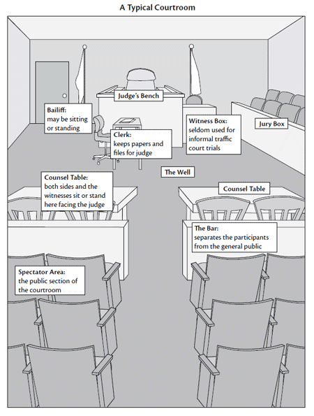 This is a rough diagram of a typical courtroom in the state of Washington. Courtrooms vary a great deal from city to city and county to county but they all have the same basic structure.